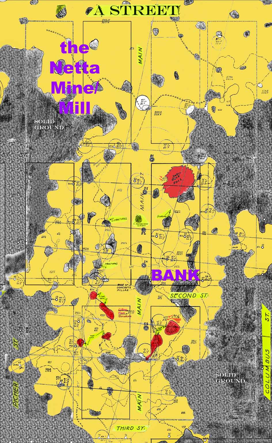
Map courtesy of Missouri Southern State University Archives (colorized by CardinKids)
Map courtesy of Missouri Southern State University Archives
(colorized by CardinKids)
|
Lead was first discovered in Picher in 1914, when a drill rig, being moved from near Commerce to Baxter Springs for rail shipment, became mired in the mud. Permission was asked, and granted, to drill right there, since the drill rig was going to be in that spot for a while (or so the story goes). This happened to be on a 40 acre allotment belonging to Harry Crawfish, a restricted Quapaw Indian. (When the Quapaw Tribe allotted the reservation to its members, each person received 240 acres. Members by blood to the Quapaw Tribe had restrictions placed on their allotment, while adopted members from other races or tribes were unrestricted as to what they could do with theirs.) The Picher Lead Company created the “Picher Crawfish” mine there. . In 1916, the Picher Lead Company, Joplin, MO merged with the Eagle White Lead Company of Cincinnati, OH, creating Eagle-Picher Mining and smelting Company. The Netta Mine was among the first in the Picher area, and just south of the Crawfish. It was certainly the most influential in Picher’s history. It could be said that it was an extension, to the south, of the Picher Crawfish. Since this land belonged to an unrestricted Quapaw, Eagle-Picher bought instead of leasing mineral rights. Of course, it had to build a mill rather than use the Crawfish, because of Indian policy. The Netta created a cavern larger than 900’ X 500’ under Picher’s Main Street, with floor to ceiling heights ranging up to 107’. After the tops were removed from five pillars, probably because of rich “dirt”, only three pillars were left to hold up the largest void. At some point in the forties, after mining ceased at the Netta, it was decided that the area under Second and Main Streets might be in danger of collapse. Reinforcement and a form were placed around a pillar very near the intersection, and a hole was drilled in front of the First State Bank, Second and Main Streets. Concrete was poured into the form from above, creating a “corset’ around the pillar. The floor to ceiling measurement at that point was ninety six feet. In January, 1950, a large cave-in (roughly 200 feet across by 100 feet deep) occurred a few miles southwest of Picher, at another Eagle-Picher mine. (It was south of Cardin, and referred to by us as "The Elephant Hump" between the Woodchuck and the Domado/Rialto) Upon hearing of this cave-in, Elmer Isern, President of Eagle-Picher mining in the area, requested an inspection of the remaining pillars of the Netta, below Main Street in Picher, among other non operating mines. That inspection determined that the “corseted” pillar was in fine shape, while the remaining two were showing signs of stress. Due to that inspection, it was determined that a four block area of downtown Picher was in danger of immediate collapse. Since Eagle-Picher OWNED the land, it was decided to vacate an area bordered on the east by Columbus St., on the south by Third St, the west by Picher St., and the north, 300’ north of First Street. In February, notices were issued to the tenants advising them to vacate the area within thirty days. There was to be no exceptions, and everyone had to vacate. There was to be no financial assistance to anyone, and the buildings that couldn’t be moved would be razed. Had that been restricted land, Eagle-Picher would have had no authority to issue such an order. That’s a far cry from today’s “buy-out”!
|
![]()